External Read: Google Map’s Moat
Ok seriously, I think i just had a brain melt moment… this is some serious geekiness.
https://www.justinobeirne.com/google-maps-moat
I was talking to my buddy Marcus about how I hated how Google Maps started doing a “smart zoom” at different points, which upset me. The argument is that they are making it “friendlier” for the masses, giving the larger perspective for people unfamiliar; but stubborn me argues that I should have a toggle that says “lock perspective”, because I don’t care about the landscape of the path, I just want to be assured I won’t miss the next turn. I’ll argue that zooming out makes the scale useless for meaningful details like next exit/turn streets, and just tells me eventually I will turn right… “mmm, ok”.
Back to the post. Justin does a great job of breaking down his methodology for reverse engineering the process. I wish “shape recognition” would have been used explicitly. Not just by itself, but to setup the fact that its more than just SHAPE recognition, its Object Recognition. Notice in the Park Shelters image, it ignores the [I assume] dirt patches. Sadly it excluded the baseball diamonds and tennis courts, but I think its due to the time the image was processed, as I’ve seen those objects called out in other map tiles before.

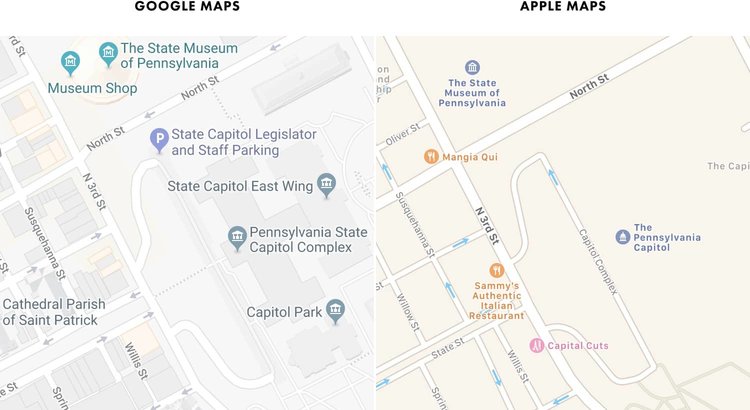
I think my favorite part is the Data Alchemy section with its Commercial Corridors and Area’s Of Interest. I want to see this to become Prescriptive, where I can plan a trip, and it will make recommendations for me as far as paths to go… not because they are the most efficient, but because they will create the most relevance to me, based on the insane data Google and Facebook have about me.
BTW, take note Google AND Apple: a 3D view while I’m driving downtown Chicago… it’s just an accident waiting to happen. Just show me the road and my turn!!! It’s hard enough to avoid the stupid people who think I can see them as they pop out from behind the elevated track beams at full hustle speed. :facepalm:

I’ll have to read quite a few of Justin’s cartography posts.